From Ortelius to oblivion: mapping the marks that punch holes in Africa’s history. Fri 24 October 2025
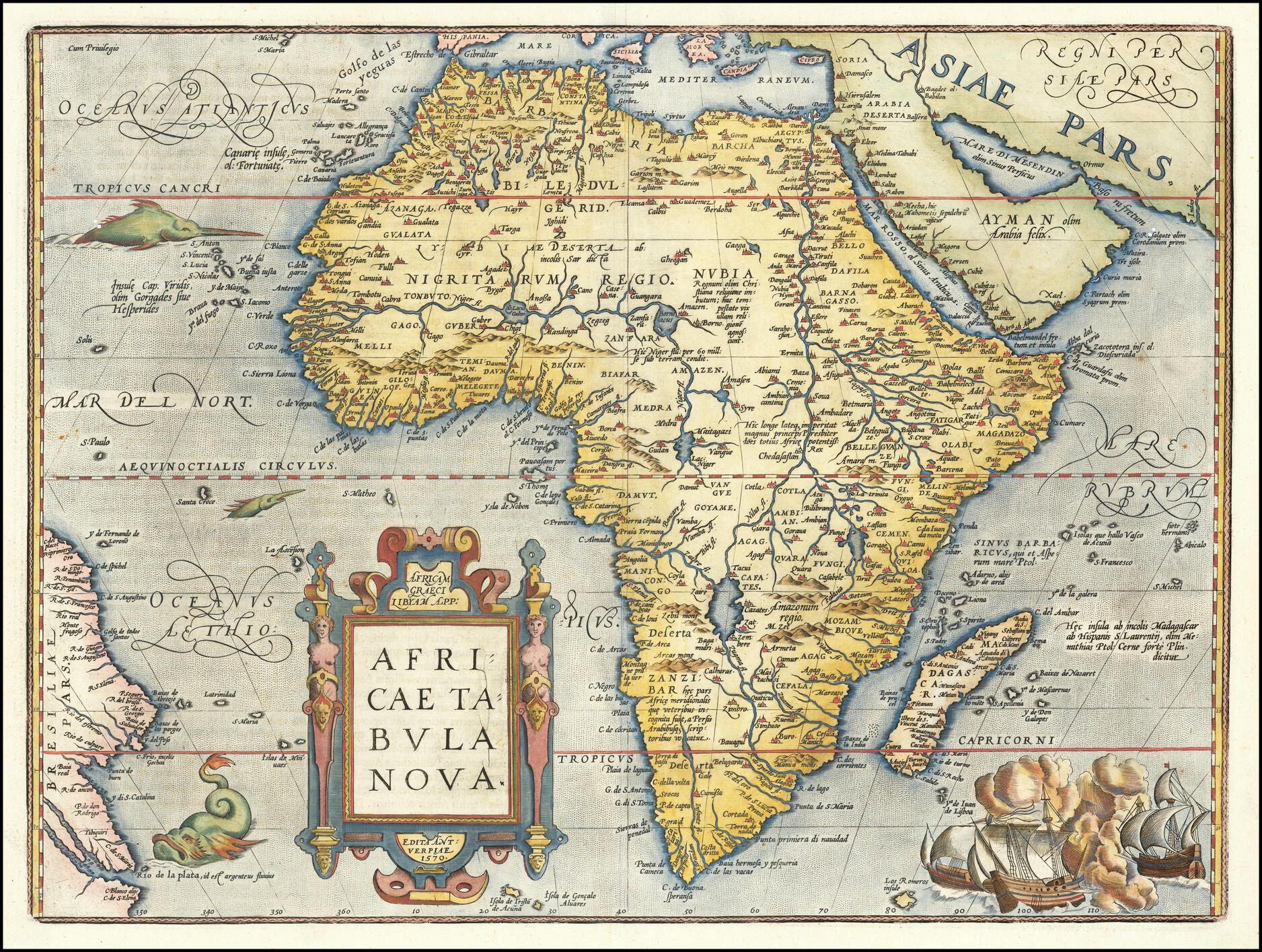
New Map of Africa, Abraham Ortelius, 1570. Source: Africae Tabula Nova - Wikipedia
Abraham Ortelius allegedly compiled this map from existing maps of Africa 1.
What happens if we overlay on to this map the patch of Libyan Desert Glass with which this Desert Forensics series began?
Libyan Desert Glass overlain on Ortelius's 1570 map
Key:
- Green marker: Libyan Desert Glass
- Green patch: Approximate area of Libyan Desert Glass patch
- Red patch: Gilf Kebir crater field
- Fire marker: Crater site
- Pink line: The Tropic of Cancer at 23.4o
Ortelius's 1570 map should show the Libyan Desert Glass patch about where he placed the settlement called 'Serta'. Perhaps that's why he drew three, blue, lake-like affairs next to towns. Perhaps he was trying to show three patches of Libyan Desert Glass.
But if so, then what happened to Serta? And to Alguechet, Augella and the other settlements in the area?
Although Serta appears to be about 360km (223 miles) east of where modern maps show the Libyan Desert Glass patch today, that's because old maps distort longitude. You can see the distortion if you zoom out the map. You'll see Ortelius positioned Africa's coasts further apart than they are shown on modern map.
This distortion is because the clocks required to accurately determine longitude didn't exist before 1773.
So Ortelius's 1570 map appears to 'widen' Africa, especially as it approaches the equator. As a result, Ortelius placed locations in east Africa to the right of where modern maps place them. And he placed locations in west Africa to the left of where modern maps place them.
If you offset the maps to compensate for that 360km difference, Egypt's area of desert glass and craters now looks like this:
Libyan Desert Glass map overlain with longitude compensated on Ortelius's 1570 map
Key:
- Green marker: Libyan Desert Glass
- Green patch: Approximate area of Libyan Desert Glass patch
- Red patch: Gilf Kebir crater field
- Fire marker: Crater site
- Pink line: The Tropic of Cancer at 23.4o
Strangely - or perhaps not - Ortelius didn't map Eqypt's pyramids. If he had, he would have drawn them slightly further east than they appear on modern maps. Although then again, if Eqypt's pyramids were older than around 1840, they would probably have merited a mention in the Bible.
Africa has plenty of enigmatic craters. There are polygonal meteorite craters missing their meteorites, impact structures, meteorite-craters-now-relabelled-as-volcanoes and the weird Hoba meteorite which lacks a crater:
African craters, impact structures, volcano craters and enigmatic landforms
- Fire marker: Crater or crater-like landform
- Red circle: Crater's approximate crater diameter
- Black marker: Hoba Meteorite
- Blue marker: Richat Structure
- Yellow marker: Alleged Hypatia comet core
- Green marker: Libyan Desert Glass
- Green patch: Approximate area of Libyan Desert Glass
Can Ortelius's 1570 map help modern maps better explain Africa's enigmatic polygonal craters, its craters-without-meteorites and its meteorite-without-a-crater?
Here's Ortelius's map superimposed on the above modern map. Bear in mind that old maps 'widen' Earth as they approach the equator:
Africa's' mystery sites overlain on Ortelius's 1570 map of Africa
- Fire marker: Crater or crater-like landform
- Red circle: Crater's approximate crater diameter
- Black marker: Hoba Meteorite
- Blue marker: Richat Structure
- Yellow marker: Alleged Hypatia comet core
- Green marker: Libyan Desert Glass
- Green patch: Approximate area of Libyan Desert Glass
More:
The maps do not show Namibia's very large-scale ridge and furrow field.
Nor do they show the 16 'natural' nuclear fission reactor remnants near Oklo, Gabon.
Allegations that African fission products have been found in the US and Siberia have led some Russians to link Africa's crater enigmas with Russia's crater enigmas.
Being a lighthearted, optimistic people, these Russians conjecture that their enigmatic craters are the scars of a mere nuclear war.
They may have misunderstood both the violence and the range of processes that created them.
Perhaps including the nature of the initial destructive blasts:
Like these but much bigger and whiter. Source: Disclosure Day - First Trailer (2026)
Along with the catastrophic release of energy stored in their "target terrains".
Nevertheless, their interpretations are worth knowing and their evidence is worth seeing.
When watching the videos below, bear in mind Youtube's auto-dub to English often presents Russian for 'nineteenth century' as 'tenth century', 'crater' as 'funnel', 'map' as 'card' and 'quarry' as 'career'.
1. Who bombed Ryazan and other cities of Russia?
URL: https://www.youtube.com/watch?v=VBAdGk2djg4 Channel: Historical Paradigma
Core Claim:
- Three large circular depressions near Ryazan visible on satellite imagery may be remnants of aerial nuclear explosions, supported by elevated radiation readings and historical map evidence of vanished cities.
Field Measurements:
- Slightly concave circular fields with vegetation discoloration
- Radiation: 10 µSv background, spikes to 35 µSv in one depression, 14–16 µSv in others
- Dimensions: 30–80m diameter; one measured 64m × 8–9m deep
- Density: ~100 depressions on 4km stretch
Comparative Analysis:
- 1991 Sasovo explosion crater: 28m diameter, 3.5m depth, ~30 tons TNT equivalent
Alternative Hypotheses:
- Iron-ore mine collapses (test via elevated iron in water)
- WWII aerial bombs (metal-detector survey for fragments)
- 19th-century war munitions
- Collapsed mining shafts
Historical Map Evidence:
- 1706 map of Muscovy shows cities (Kusuga, Alexin, Bedela, Ryazan) that have since vanished or relocated.
Conclusion:
- Multidisciplinary research (radiological, hydrological, archaeological, archival) urgently needed to determine true origin.
2. Nuclear Strike Origins: Isotope & Crater Analysis
URL: https://www.youtube.com/watch?v=ED7BM-Cp8bQ Channel: Неофициальная История
Core Claim:
- Nuclear weapons were launched from Africa and Australia against Siberia and North America approximately 180 years ago (early 19th century), proven through uranium isotopes, crater dispersion ellipses, and cesium-137 dating.
Three Lines of Evidence:
-
Isotope Fingerprinting
- Each uranium deposit has a unique radiation "fingerprint" (like human fingerprints)
- African uranium traces found in North America
- African + Australian uranium traces found in Siberia and Russian Far East
-
Crater Dispersion Geometry
- Spatial distribution of nuclear-type craters in Siberia forms azimuthal ellipse pointing due south
- Direct line toward Africa and Australia
-
Radiochemical Dating
- Cesium-137 (only forms during nuclear fission) confirmed in crater soils
- Lake Svyatoye (Ryazan region): 357–360m diameter = 1 megaton blast
- Current Cs-137 activity (~3 Bq/kg, ~350g total) with 30-year half-life = 6 half-lives = 180 years ago
Conclusion:
- Two direct facts (isotopes + crater orientation) prove nuclear strikes from Africa/Australia. Dating places events squarely in early 19th century, not prehistoric or medieval times.
3. 19th-Century Apocalypse: Multi-Stage Catastrophe
URL: https://www.youtube.com/watch?v=XycYgA0kTzs Channel: Неофициальная История
Core Claim:
- A comprehensive global catastrophe in the early 19th century—artificially triggered nuclear war followed by cascading natural disasters—destroyed an advanced civilization. Official history deliberately fragments this unified event to maintain control over survivors.
Multi-Stage Catastrophe Timeline:
- Nuclear War: Six global powers exchanged strikes (Africa, Australia, Indo-China, Antarctica/"Atlantis", Hyperborea, South America)
- Carpet Fires: Nuclear blasts ignited global firestorms, burning organic matter and lifting it into atmosphere
- Earthquakes & Volcanoes: Explosions triggered seismic activity; volcanic ash added to atmospheric load
- Dust Storms: Massive wind erosion lifted billions of tons of soil
- Atmospheric Collapse: Suspended particles condensed water vapor, disrupting thermodynamic equilibrium
- Acid Mud Rains: Nitrogen/sulfur oxides produced nitric/sulfuric acid; "mud flood" lasted ~2 weeks
- Sea-Level Rise: Ocean rose >100m; Bering Strait formed; Antarctic ice sheet grew; permafrost established
- Climate Shift: "Year Without a Summer" (1816) = nuclear winter; atmospheric pressure dropped from 8 atm to 1 atm
- Mass Die-Off: Tens of billions killed by radiation, oxygen starvation, caisson disease, exposure
- Genetic Mutations: Human races emerged from radiation-induced mutations
Geochemical Evidence:
- 2m-deep layers of clay and ash containing cesium-137
- 390m-diameter craters = 1 Mt surface bursts
- Radiation readings: 10 µSv background, spikes to 35 µSv
- ~100 craters on 4km stretch near Ryazan
Post-Apocalyptic Social Engineering:
- Survivors were divided into artificial nations, races, languages, and religions by new ruling elites ("Bible project" for unified religious control; Norman Conquest = African elite takeover of England). Abolition of serfdom motivated voluntary resettlement of Siberia (three waves; 53,000 from Tula alone).
Warns viewers:
- Official historiography deliberately falsifies chronology to prevent recognition of patterns. Only "opening truth to people" can prevent recurrence.
4. 1830 Missile Strike Over Russia from Africa
Some Russians think they fought Africa.
And Africa fought back:
URL: https://www.youtube.com/watch?v=e_iuc_Wd-wY Channel: Разгадки истории
Core Claims:
- Historical events of the second half of 19th century were "copied" and transferred to the first half by historians, creating parallel timelines
- An 1830 "fireball" incident over Tula, Russia was not a meteorite but an intercontinental cruise missile launched from Africa
- "White Africa" possessed advanced weapons capable of bombing the entire northern hemisphere
- Ancient Yundum airfield in Gambia provided infrastructure for launching such missiles
Key Evidence:
-
~200 chronological duplications between first and second half of 19th century:
- Alaska border determination and sale
- St. Isaac's Cathedral construction dates
- Decembrist revolt and First of March assassins (both groups of five)
- Parallel biographies of composers and writers
-
Byron's 1816 poem "Darkness" mentions "war flared up again"
-
Coinage anomalies: First half 19th century coins lack portraits; first named kopeck 1841
-
1912 Borodino veterans meeting raises questions about 1812 war dating
-
Leo Tolstoy's Crimean War service (from 1854) and similarities to "War and Peace"
-
Photo comparison: Prince Napoleon Bonaparte (1854) vs. portraits of Napoleon I
-
Pushkin/Lermontov poems: No mention of 1812 war leaders
-
WWI renaming: Originally "Second Patriotic War" before revolution, later "First World War"
1830 Incident Details:
- Three police archives document "fireball" and explosion over Tula
- Object traveled 42 km in 53 seconds (≈2.4 Mach or ≈2,850 km/h)
- Speed incompatible with meteorites (max ≈43,200 km/h—would have been much faster)
- Characteristics match SM-62 SNARK intercontinental cruise missile (1955):
- Range: 10,180 km
- Speed: 1,500 km/h
- Warhead: 4 megatons
Yundum Airfield Evidence:
- Ancient basalt-paved runway in Gambia suitable for heavy aircraft launches
Conclusions:
- 1830 incident was artificial weapon strike, not natural phenomenon
- Weapon similar to SM-62 SNARK indicates 19th-century long-range technology
- Gambia's Yundum airfield enabled systematic bombardment of northern hemisphere
- Hidden parallel history exists requiring archival and archaeological investigation
- Africa's military role in 19th–20th century conflicts must be reassessed
5. 19th-Century Nuclear War: Africa vs. Hyperborea
URL: https://www.youtube.com/watch?v=H7W4Ni4P-wM Channel: Разгадки истории
Core Claim:
- A catastrophic global nuclear war occurred in the early 19th century between a southern coalition (white population in southern Africa + allied Australia) and a northern "Hyperborean" bloc (Eurasia, North Africa, North America). This conflict has been systematically hidden for 200 years.
Multidisciplinary Evidence:
- Uranium isotope fingerprints: Unique African and Australian uranium signatures found in North American and Siberian soil
- Kamilla irrigation complex: 67-million-acre high-tech agricultural system in southern Africa, visible in Google Earth, capable of feeding 5 billion people
- 1830 fiery sphere: Police reports in Tula, Russia, trace flaming projectile trajectory to Ghana/Togo/Benin/Algeria/Libya
- 18th-century poem: Literary evidence of "African fleet" landing in Russia under Catherine II
- Carpet bombardment: Widespread nuclear cratering across northern Kazakhstan and Siberia (round lake-craters)
- Basalt runway: Ancient paved landing strip at Yundum, Gambia
- Sealed aircraft: Buddhist stupas in Sri Lanka and India reportedly enshrine "vimananas" (ancient aircraft)
Concealment Motive:
- Mutual annihilation created a power vacuum enabling Western European nations - particularly England - to easily colonize vast territories, imposing fabricated identities, languages, religions, and histories ("divide and rule"). The belief that nuclear war renders regions uninhabitable for centuries was deliberately promoted to discourage investigation (Hiroshima/Nagasaki demonstrate reinhabitability within decades).
6. Dating Tula's Craters
Source: Тайна кирпичных небоскрёбов в полях и кладбищ рядом
Says fireballs were seen over Tula in the 1830s.
Proposes Tula's religious ruins are the damaged remains of industrial facilities. Contrasts craters caused by collapsed mines with craters that apparently have no conventional explanation.
© All rights reserved. The original author/creator of each image, video, quote or text retains full ownership and rights.
![]() More of this investigation:
Desert Forensics,
More of this investigation:
Desert Forensics,
![]() More of this investigation:
The Reformation Was a Reformatting,
More of this investigation:
The Reformation Was a Reformatting,
![]() More of this investigation:
Fingerprints of the Clean Up Team
More of this investigation:
Fingerprints of the Clean Up Team
![]() More by tag:
#radiation
More by tag:
#radiation