B&Q was closed, so we improvised. Fri 12 November 2021
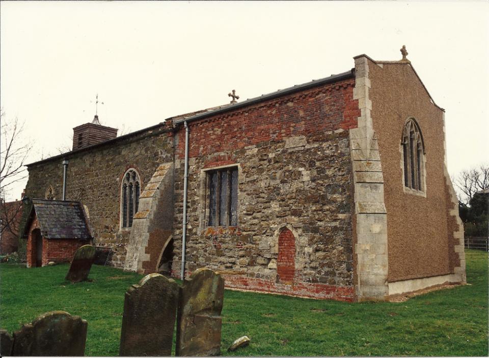
All Saints church, Great Sturton, Lincolnshire. Source
Its 'tower' is made of wood.
From Lincolnshire Churches: All Saints, Great Sturton:
As the population declined the building was gradually reduced in size and its exterior and interior walls show evidence of a lost north aisle, a west tower and the truncation of the chancel.
However, churches that were "gradually reduced in size" look like this:

Consistent building material gives the game away. Source: Stephen Parker
While Great Sturton looks as though it was gradually increased in size. Slapped together from the rubble of other structures.
Location: All Saints church: (Google Maps), (Google Streetview), (OpenStreetMap), (NLS), (Flickr images)
With our lie detectors now switched on, what else do we discover about All Saints' relationship to the size of the local population?
From All Saints (Wikipedia):
There are two deserted medieval villages listed for Great Sturton; one was Sudtone, the other the hamlet of Lowthorpe.
The first Sturton Hall is a Grade II listed ruin. The house was deserted in 1810...
So All Saints served one village, a hamlet and perhaps a hall. Let's get an idea of how big All Saints really was:

Look at the arches on that. Source
The residents of Sudtone, Lowthorpe and Sturton Hall must have been a very devout.
Seen from this angle, it seems the structure of All Saints really was bigger in the past. That three vaulted sub-structures once joined on to this wall. The bodgy cobbling together of a complete building out of the remaining wall suggests All Saints was reduced to a small ruin then only partially rebuilt using whatever material was available.
It suggests there was a period where there was no church.
Great Sturton's depopulation, says Lincolnshire County Council, was caused by an unspecified "economic decline". However, White's Directory of Lincolnshire of 1856, has a slightly different take:
At the enclosure (approx 1800), a great part of the parish was in a sterile condition, and 237 A[cres]. were allotted to the vicar, and 160A[cres]. to the impropriator, in lieu of tithes.
No people, lots of land. Just a couple of managers - vicarii - to organise its re-stocking.
Further north - at Bamburgh, Northumberland - a similar pattern is visible:
Cottaging in Bamburgh. Source: Villages by the Sea - Bamburgh
Similarities:
- Two sub-tenants in charge of restoration
- Earlier, bigger structures rebuilt as smaller structures
- Era: in the 18th century
As an aside, note his casual comment about pantile roofs being an 18th century innovation. Pantiles are generally considered a Roman innovation...
Does Great Sturton's depopulation tally with conventional views on English Civil War population losses?
From History.com:
An estimated 200,000 English soldiers and civilians were killed during the three civil wars, by fighting and the disease spread by armies; the loss was proportionate, population-wise, to that of World War I.
But were British buildings being 'carefully reduced in size' after World War I?
No.
Either Great Sturton's population took a disproportionately big hit in the Civil War. Or Britain's 200,000 Civil War dead is a national understatement. And neither option explains why this builder's bodge of a church is being presented as a 'gradual reduction in size'.
So what did happen? And when?
The reason we don't know 'when' is because we keep being told Britain's destruction and depopulation event began about 1,000 years earlier than it really did. We're told it started when the Roman empire collapsed in around AD 450. When Britain's Dark Ages began:
"There is no evidence for a struggle." Source: Is The Anglo-Saxon Invasion Of England A Myth?
He's right. There was no hole in British society. At least, not in the years after AD 450.
Britain's physical evidence suggests the hole in British society had appeared around AD 1650. About the time the Little Ice Age temperatures really bit in.
That's why there is no evidence for a struggle. By the end of the 17th century, there were too few British left to fight. The Anglo-Saxon invasion isn't a myth. It's just:
- re-dated to 1,000 years before it happened.
- And presented as an invasion rather than repopulation.
What follows is just a sample of the available evidence for this claim. It shows eastern England was a mess by 1697. It's not just churches, mansions, halls and villages that were in ruins. Towns and cities had been turned into rubble too.
TL; DR
| Year | Witness | Blames destruction on: | Evidence suggests: |
|---|---|---|---|
| 1697 | Rev. Abraham de la Pryme | Rebellion, geomorphological change, fire | As described |
| 1730 | Rev. William Stukeley | Fire/flood/The Deluge | Flood |
| 1791 | John Byng | Rebellion/War and fires | War, flood plus fire |
| 1830 | Rev. George Oliver | War, flood | War, flood plus geomorphological change |
| 1846 | Rev. Abner W Brown | Not stated | Flood/geomorphological change |
Sample witness statements:
From The diary of Abraham de la Pryme, the Yorkshire Antiquary, Abraham de la Pryme, 1697, p79, dated 1696-02-05:
At Upper Reasby there has been a pretty large handsome town formerly, but now ’tis all vanished but one single large farm-house.
Upper Reasby is now High Risby. (See map of Risby)
On p80, dated 1696-02-07:
This day I made another journey, and that was to Rantrop to enquire for antiquities there. I find that it's true name is Ravensthorpe, and that there has been a town there, as is apparent from the foundations of many houses.
All the houses at this Ravensthorp is now but three or four.
He's describing Raventhorpe medieval settlement.
On p81, 1696-02-07:
...went to Castrop in this parish, which town was formerly call'd Castlethorp... here are a great many foundations of houses to be seen.
On the east side on the town, on your right as you go down to the commons, here are a great many foundations of houses to be seen. It has been as bigg again as it is, and was once a parish of itself.
On p127, 1697-04-21:
This day I took my horse and went to see a place called Grainstrop, which lys in a hollow on the right hand, and about the middle way, as you come from Kirton, formerly called Chiric-town, to Scawby. Tradition says that the aforesayd Gainstrop was once a pretty large town, tho' now there is nothing of it standing but some of the foundations. Being upon the place I easily counted the foundations of about two hundred buildings, and beheld three streets very fare.
Tradition says that that town was, in times of yore, exceeding infamous for robberys, and that nobody inhabited there but thieves ; and that the country haveing for a long while endur'd all their villanys, they at last, when they could suffer them no longer, rise with one consent, and pulled the same down about their ears.
At Alkborough (Google Maps), (Google Streetview), (OpenStreetMap), (NLS), (Flickr images) on p138, 1697-05-29:
There is a pretty good church there (St John the Baptist church), but no epitaphs nor monuments in it at present visible, because that the chancel, being fall’n, has buried all.
On p139, 1697-05-30: At Whitton, a former port a few miles to the east of Alkborough on the banks of the Humber:
About twenty years ago was part of a great hall standing on the west side of the church, in a cloase where the Mortons lived, but now onely part of the foundations appear.
Location: Whitton (Google Maps), (Google Streetview), (OpenStreetMap), (NLS), (Flickr images).
Pryme then says the Humber broke through the once contiguous Lincolnshire and Yorkshire Wolds. He quotes a rhyme as evidence the dangerous Humber rapids known as Trent-Falls used to be at Whitton. Now, he says, Trent-falls have migrated miles upstream. In other words, the Humber is fast wearing away its own channel. As it still is today. He says the hills the Humber broke through are scattered downstream along the northern side of the estuary, posing a hazard to shipping.
Confirmation that Pryme wasn't making this up comes from Lincolnshire geographer HH Swinnerton. Swinnerton neatly sidestepped the Humber's challenge to geographic science in a November 1937 talk to the Lincolnshire Union of Naturalists. He simply said:
For reasons which need not be discussed here, the Humber river was able to deepen its valley more rapidly than did the Lincoln river.
Back to Pryme... On p140:
I went to West Halton. This town tho’ it bee but little now is nevertheless of great antiquity. It’s parish is very large, which [is] also a good sign of its antiquity. The church is all now fain to ruins, but appears to have been very stately, magnificent, and larger than any one for a great many miles round about it. There are two great bells lyes buryed amongst the rubbish
Sounds like Pryme thought West Halton was once larger. All we know is that it's church was destroyed by 'fire' in 1692 and rebuilt in 1695 - two years before Pryme visited.
Location: West Halton: (Google Maps), (Google Streetview), (OpenStreetMap), (NLS), (Flickr images).
On p141, Pryme says almost all of Caistor was burned down in 1669. 20 years after the Civil War ended. He says:
it is observed that every town is betterd exceedingly by being purified by fire.
On p142, Winterton church is:
in such a state of decay that, for many years after ye Restoration, there was scarce either a bit of glass in ye windows, or of lead upon ye roof, or any good timber about it. It lay almost open to all storms, so that if either rain or snow fell ye congregation were sure to suffer thereby.
Location: Winterton: (Google Maps), (Google Streetview), (OpenStreetMap), (NLS), (Flickr images)
On p149, at Hibaldstow:
Not far off the Roman street that runs by Hibberstow, in Hibberstow Fields, appears to have been the foundations of many buildings. Tradition says that there has been an old citty there. I asked all ways that I could imagine to know the name thereof, but they could not tell me. Not farr from it is a place where tradition says stood a great castle belonging to this citty.
Location: Hibaldstow: (Google Maps), (Google Streetview), (OpenStreetMap), (NLS), (Flickr images)
On p153, 1695-10: at Grimsby:
I went to Little Coats, about which are many foundations of buildings. From thence to Grimsby. Grimsby is at present but a little poor town, not a quarter so great as heretofore. The old market place is lost, and that where they now keep it is in the midst of a street. There is scarce a good house in the whole town, but a larg brick one, which Mr. Moor, their parlament man, has lately built.
The church, which is now standing... is a noble larg building of great bigness, built in form of a minster, but it all falls to decay, the whole town being not able to keep it in repair, they being so poor, and it so larg.
After listing its demolished ecclesiastic buildings, Pryme attributes Grimsby's decline to:
- Changes in the coastline north and south of the town.
- The demolition of the monasteries.
- The rise of Hull.
What changed Lincolnshire's coastline?
Traditionally, plague is blamed for Lincolnshire having more than twice as many 'Deserted Medieval Villages' than any other county.
Plague?
How would plague change the coastline north and south of Grimsby? Or increase the Humber's ability to erode its bed miles westwards?
Pryme noted reports of strange geology arriving at east Yorkshire's coast. He says it is like bismuth or 'tin glass'. Which may explain the sudden development of its Victorian alum extraction industry in hard-to-believe circumstances.
Around thirty years after de la Pryme toured Humberside, Rev. William Stukeley toured eastern England.
Stukeley gives the game away very early on. In Itinerarium Curiosum, 1776 edition, on p18, he says:
In every parish formerly were many chapels... though now most of them are demolished, at what time I cannot imagine.
That's odd. You would expect a reverend writing in the 1700s to know about Henry VIII's 1540 dissolution of the monasteries and about the 1642-1651 English Civil War. The English Civil War that ended about 80 years before he was writing.
The Dissolution and the English Civil War are the two events during which chapels were damaged or demolished. Or so we are told.
Perhaps at the time Stukeley was writing, modern narratives of Henry VIII's Dissolution of the Monasteries and the Civil War had not yet been created.
Stukeley says south Lincolnshire's coastline has also changed. Five miles inland of Boston and Skegness in southern Lincolnshire, a large harbour has silted up and become marsh. Using land levels and local recollections, he outlines the original course of the river Witham into the sea just south of Wainfleet.
What's left of its north bank port is here:
Wainfleet medieval port.
There are still people alive, Stukeley says, who knew people who remembered the Roman road that ran north west from the now filled-in harbour to Horncastle. That dates the usability of Salter's Road to around 1620.
Stukeley also says England's Kent coast has changed. From Itinerarum Curiosum, p126, describing the English Channel coast south of Sandwich, Kent:
This flat coast is fenced against the ocean by the sand-downs, which in Lincolnshire we call meals: but within the memory of man, as they told me, the sea has commenced a new method of guarding against its own violence, by covering the shore, for a great depth and height, with the pebbles afore mentioned; which is an odd mutation in nature; and it is observable that these pebbles come from the south.
And at Dover:
the water formerly came a good way higher up, and made a large port; and they have found anchors above the town.
That tallies with other south coast towns that had inland harbours until a series of storms in 1287 (Hastings, Winchelsea/Rye/Romney Marsh).
But depopulation wasn't only a coastal phenomenon.
From The Family Memoirs of the Rev. William Stukeley, M. D. - Vol III, p54, 1736-02-11:
I went to Silberton, in Wansford 1 parish... Siberton lodg (as now called) is now the only house in this once considerable town
All about here, for many acres of ground, lyes the extended carcase of a large town, houses and streets very visible.
The building now called Sibberton Lodge.

Sibberton Lodge today. Source
Sibberton's disappearance is attributed to plague. And its shortage of remains is attributed to quarrying:
South of the deserted village site and A47 are enormous quarries, stripping away the land that the medieval inhabitants of Sibberton would have known well. Prior to quarrying, a number of assessments were carried out which identified a number of early medieval features including evidence of metalworking, ditches, pottery, and animal bones. It is very possible that these items related to the inhabitants of Sibberton as they worked the land around the village.
Noting inconsistencies in the chapel's history, the author also asks:
which does beg the question what happened to the chapel between the 14th and 17th centuries?
Good question. For more on this area's destruction - and on possible evidence-removal at quarries - see Location Analysis: Peterborough-Stamford Wild Hunt - Part One.
Or just stick with Stukeley for a while.
Wherever he goes, Stukeley hears accounts of rubble lying just under the soil; of Roman artefacts being dug up everywhere.
And of bodies.
From Itinerarum Curiousum, William Stukeley, 1766 edition, p22, at Holbeach:
in Wignal's Gate, near Holbech hall, by the river side, dedicated to St. Peter. About 1719, I saw many corpses dug up in the yard at making a ditch there.
Describing Burgh le Marsh, Lincolnshire, on p29, Stukeley says:
At Burgh, bodies are commonly dug up in gardens and yards.
Having pointed to evidence of earlier higher sea levels, Stukeley blamed 'The Flood' and 'The Deluge' for the bodies. And for other odd finds.
From Itinerarium Curiosum, 1776 edition, p37:
I saw a piece of oak wood, as big as both one’s hands, lie between the strata of solid stone : though petrified, the ligneous fibres when split would burn in a candle. I suppose it to have been lodged there in the deluge.
Deluge does not explain the destruction inland and on high ground. Only in the Bible and in science fiction:
The waters below; the waters above. Source: Attraction 2: Invasion
It's a riff on Genesis 1:6 - 1:7, which describes Earth as an artificially-created air-space between 'the waters below and the waters above'.
Like de la Pryme, Stukeley also found whole towns had been burned down.
From Itinerarium Curiosum, 1776 edition, p37:
we went to Northampton, the most elegant town in England : which, being wholly burnt down, is rebuilt with great regularity and beauty.
Belvoir Castle stands on a hill 40 miles from the coast.

Belvoir Castle in 2022. Source
Belvoir Castle wasn't always a stately tourist magnet.
In The Torrington Diaries: Containing the tours through England And Wales of the Hon. John Byng (Later Fifth Viscount Torrington) between the years 1781 and 1794, , p133, visitor John Byng describes his 1791 visit:
Here Belvoir-Castle rises to the View, in awful State: In our way we passed by the ruin'd Church of Woolsthorp the Church Yard of which is still used as a Burying Ground.
We then walk'd up The Hill Belvoir-Castle, where every thing is in neglect, and Ruin, and in such a state it has long been;
The Housekeeper soon came; of a very drunken, dawdling appearance.
...in the whole House, there is no Furniture (Pictures excepted) that a Broker would think worth the carrying away; Nor one Chair, Table, Carpet or Curtain of use or comfort! In this Condition was the House found by the late duke 2; who, instead of refitting, repairing, and such like necessary and honorable Works, laid about him, like a dragon to buy Pictures... but they are all tost about in confusion:
There is also a long Gallery where the Pictures (a wonderful Collection of antient and modern Skill) are not yet hung up: a Large Room, like an auctioneers Room, leading from this, is filled by fine Paintings, piled about, at all corners.
There is an old Shabby Chapel; disused to Prayers; and instead of the necessary number of Servants, but 4 of any description are retained.
...at present there is not an habitable Room, or a Bed fit to sleep in.
Out of Doors there are no Improvements, no Pleasure Grounds—and as at Grimsthorpe not a Rose Bush to be seen; as if for the last 100 years all had been left to Ruin.
It's due to the English Civil War, Byng says.
Belvoir was attacked in the English Civil War and surrendered after a three-month siege. But it's hard to believe a once-sumptious English castle far away from - and high above - that changing coastline was unoccupied and - apparently unfurnished - for 140 years.
Unless there were too few people around to occupy it.
From The Torrington Diaries (Abridged):
On p144, 1789-05-31: Sandy, Bedfordshire:
this Country might, like China, be under eternal cultivation ; (the more People and the more Stock, the more Product;) and none of the present idle fallow work, want of Population
p334 1791-06-20: Ramsay, Cambridgeshire:
in old Abbey House... there are no old pictures, no books, and what is more extraordinary, not one servant therein
p335 1791-06-21: Hamerton, Cambridgeshire:
Hamerton seems, truly, the deserted village: cottages fallen and falling! These led me (properly,) to the great ruin of a magnificent family hall; (belonging with the village to Mr Barry of Cheshier;) near to which an Irish surveyor was standing, giving orders for the demolition.
Those who travell with fashionable haste, (or slowly for the first time,) will not discover the decrease of halls, farms, and cottages; but I well-acquainted with the county of Bedford can sigh over the decay of its yeomanry and cottages: so may I suppose of this county ; and most wretchedly does Hamerton proclaim it.
Nine days later, Byng surveyed Lincoln Cathedral. He says:
was shewn the cloisters, now in great disorder, but going to be repair'd;
and
and to the library, wherein a great collection of old manuscripts are soon to be arranged: but my guide knew nothing ; and I could not find any finely illuminated.
Which implies Lincoln Cathedral was being tidied up. Byng then drops a hint:
I went to view the ruins of the old bishops palace, which I was shewn by a silly gardener ; and if a sight of caverns, sutteranes (ie tunnels), door ways (ie arches) and ruins, is wish'd for, here is enough to serve an antiquary for a week; a glut likewise for a draughtsman. I left no corner unexplored ; the gardener remark'd 'that these were fine places before they were inherited' ;
'Inherited'?
Byng was part of a team working for a relative of Lincolnshire's 'Bertie family' - the family of Lord Vere Bertie, AKA the Duke of Ancaster (Google Maps), a town near Sleaford (Google Maps), (Google Streetview) in Lincolnshire. They were trying to locate and examine the ruins of religious buildings and big halls.
In Torrington Diaries, Byng reports fields littered with stone rubble. But Byng also says:
- Some churches are being restored,
- Others are still ruined and/or covered with vegetation, their interiors sometimes draped with green slime.
- Few people go to them. Byng occasionally suggests how to 'sell' Christianity.
- New owners without a clue have taken over the empty, ruined stately homes.
- The ground floor ruins of roofless buildings are sometimes occupied by new families.
- The locals can't give directions, not even to local places.
- The locals have no idea of their area's history.
- Many look foreign (Spanish in one case, more often Flemish). And Byng himself capitalises as if he were Germanic.
- Few of the locals can cook - a criticism still made of the English.
- Roman artefacts are being found and Roman coins have become so popular they are now being forged in Birmingham.
Birthplace of Henry IV - Bolingbroke, Lincolnshire - reduced from a market town to a village, Byng says.
A couple of times, Byng says such and such a big hall or house was burned down 60 years ago (approx 1730). When he blames anything for the destruction he encounters, he blames the 'rebellion' or 'the war'. Presumably he means 'the Civil War'. But that was 140 years earlier, not 60 years.
And his descriptions sound more like flood damage than fire: From John Byng's Torrington Diaries, p138-139, here describing The Priory Church of St Peter in Thurgarton, Nottinghamshire:
The inside is dark and damp, as the Church Yard Ground has risen considerably.
Wikipedia's Thurgarton page has some telling comments too:
It was restored in 1853. Parish registers exist from 1721, whereas earlier records were lost in 1780.
Funny that.
Location: The Priory Church of St Peter, Thurgarton: (Google Maps), (Google Streetview), (OpenStreetMap), (NLS), (Flickr images)
By 1846, Rev George Oliver was being paid to help rebuild Lincolnshire. He's helping to set up Sunday schools and the start of today's education system. He gushes about the progress of Lincolnshire's rebuilding:
- Churches are being rebuilt. Congregations are up.
- The land is fertile and being planted with trees. (the fens are well-known today for having few trees, though there are very long oaks lying horizontally underground)
- He claims the bad old days of barons and manors are gone.
- But Oliver also gives a lot of evidence that the land between Lincoln Edge and the Wolds was inundated until around 1730. See A History of the Holy Trinity Guild at Sleaford, Chapter I, p7.
- Despite evidence of flood, Oliver blames the ruins on Cromwell and the English Civil War.
Former towns were still being gleaned for resources in the 19th century. On high ground between Stamford and Grantham, poet John Clare was being paid to dig bones out of the fields around the village of Pickworth. He burned them for lime. There were enough to feed a lime kiln, which still stands: (Google Maps), (Google Streetview)).
In his autobiography - John Clare by Himself, p21 - Clare says Pickworth's ruins extended for two miles.
From The Victoria History of the County of Rutland Volume 2, edited by W. Page, 1935, p265, p267:
Pickworth... seems by its large stretch of old foundations and ruins to have been a town of some magnitude in past times tho it is now nothing more than a half solitude of huts and old farm houses... the marks of the ruins may be traced two miles or farther from beginning to end.
Grantham Historical Society found evidence that possibly dates Pickworth's destruction:
in 1491 it was said to have no parishioners, and in 1598 "there is no house there nor church". By the C18th, only the church steeple remained (called Mockbeggar) and this was taken down in 1728-31. The village was revived in the C19th.
Like Belvoir Castle, Pickworth is sited on relatively high ground: the southern end of the limestone Lincolnshire Edge between Grantham and Stamford.
So is the village of Folkingham. From Highways and Byways in Lincolnshire, Willingham Franklin Rawnsley, 1914:
The wide street seems to have been laid out for more people than now frequent it.
Looking further inland...
From Anglican Churches Before the Restorers - A Study from Leicestershire and Rutland, The Archaeological Journal, Geoffrey Brandwood, 1987, p385:
There will have been a good deal of truth in the following report about an unspecified church, six or seven miles north-west of Melton Mowbray, from a correspondent to Stamford Mercury, I7 March 1848, p2:
I found that the tower ... was converted into a plantation, and that some large trees were growing out from the top. Curious to know whence they derived their support, I looked inside, and saw a mass of green putrid matter running all over the walls, and the place in a condition such as I would not see my pig-sty in ... The trees on the tower are so large as to quite endanger its stability.
The church was probably St Lukes at Upper Broughton. It was restored seven years later.
From On Some British Kistvaens (Stone Coffins) Under the Present Churchyard of Pytchley, Northamptonshire, The Archaeological Journal, June 1846, by the Rev. Abner W. Brown, Vicar of All Saints church, Pytchley:
Like many other country churches it had a coating of green mould or moss for five or six feet up the walls inside, and in winter and rainy weather the water soaked in from the outside and stood in pools in the remote corners of the church floor.
Possibly this constant wet may have assisted to preserve the ancient bones from entire decay. The enormous accumulations of soil outside of the walls have now been removed down to the level of the floor: and a drain (in some places nine feet deep) has been carried across the churchyard, and has effectually dried the church.

"Enormous accumulations of soil outside of the walls have now been removed..." Source
Pytchley is 95 meters (311.68 feet) about sea level. This wasn't caused by a high spring tide in the North Sea.
Where did Brown's "enormous accumulation of soil outside the walls" come from?
Evidence of 19th century repopulation also shows up in churchyards - few have commoners' gravestones older than 1800.
These descriptions are just a sample of the accounts in 17th - 19th century travel journals. There are many more accounts of ruins and ruined churches.
Locations mentioned in this evidence collection
Key:
- Blue: Ruined churches (and one 'castle')
- Yellow: Vanished towns
- Red: Burned down towns
- Green: Rearranged coastline
- Black: Many corpses being dug out
The destruction of several locations could be marked with more than one colour. Grimsby's coastline also changed (it dried out) and parts of the town were burned by a strange fire from the northern sky.
Similarly, Pickworth was a large former town before its high corpse count made it a source of bones for lime kilning.
The black markers may help date the destructive event. Seventeenth century accounts of Burgh-le-Marsh and Holbeach are of 'bodies'. Nineteenth century accounts - such as Pickworth - are of bones.
© All rights reserved. The original author/creator of each image, video, quote or text retains full ownership and rights.
-
"Walmesford, commonly pronounced Wandsford. The south side of it is in Hunts, the north in Northants, separated by the river Nyne. A Roman kiln was discovered at Sibson, near Wansford, by Mr. Artis, in 1844.— Godwin's Engl. Archeol. Hand-book, p. 60." ↩
-
Ostensibly, per BelvoirCastle.com, that would be John, 3rd Duke of Rutland (between 1721-1779). ↩
![]() More of this investigation:
Depopulated England,
More of this investigation:
Depopulated England,
![]() More of this investigation:
The Reformation was a Reformatting
More of this investigation:
The Reformation was a Reformatting
![]() More by tag:
#Tennyson friend, #geology
More by tag:
#Tennyson friend, #geology