Visual evidence shows English buildings derelict and overgrown in the 18th century. Vegetation grows from the upper edges of walls and roofs. How? Thu 11 November 2021

Boxgrove Priory in 1737 Source: RareOldPrints
Boxgrove Priory (Google Maps), (Google Streetview), (OpenStreetMap), (Flickr images)
Notice anything?
Hint: pay attention to the vegetation growing high on the ruins:
What happened? Source: The Ships of Heaven
More English ruins from the 17th and the 18th centuries sampled from Rare Old Prints' 'Abbeys' collection:
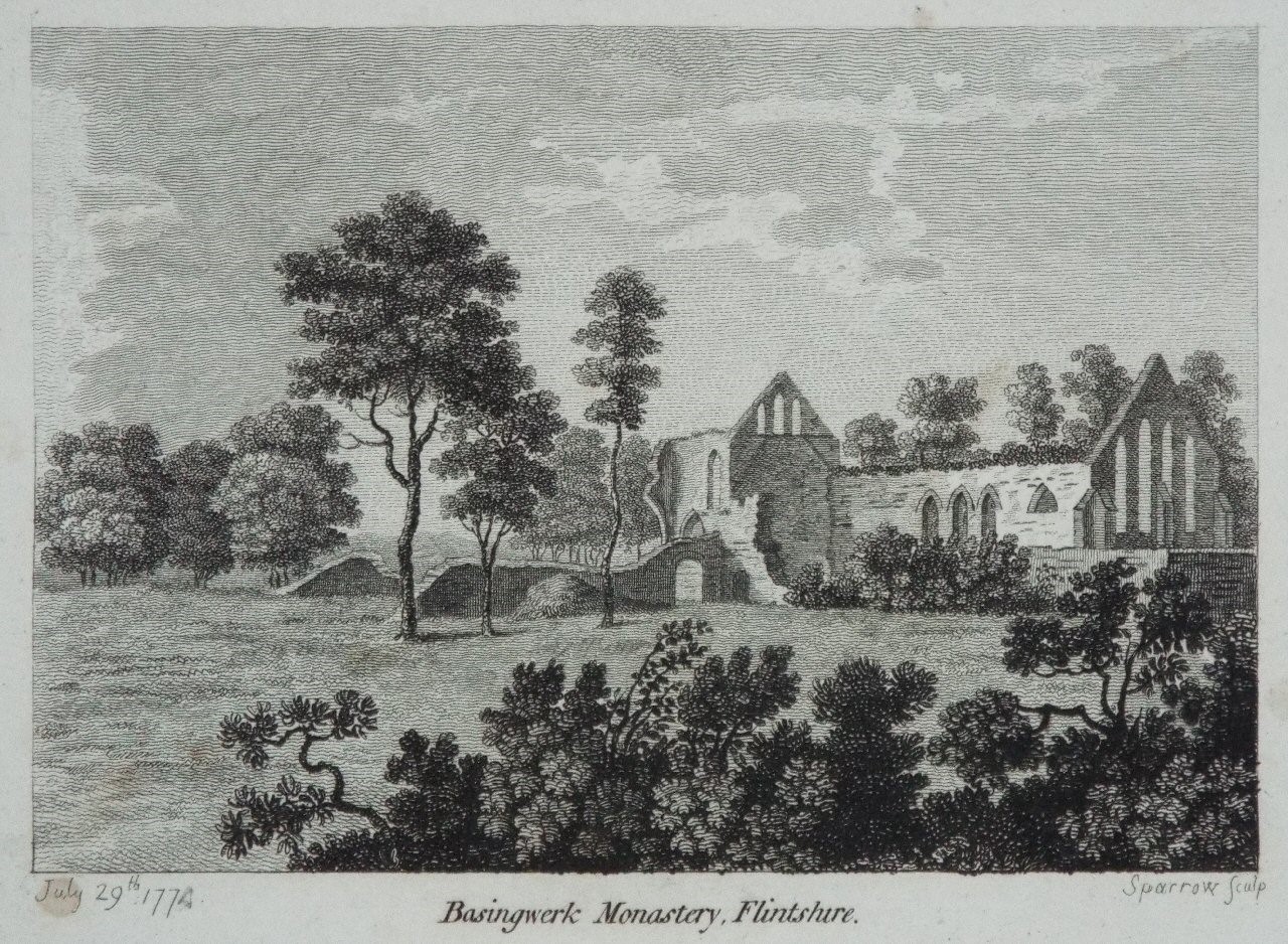
1774: Basinwerk Abbey. Source: RareOldPrints
And 31 years later:

1807: Basinwerk Abbey. Source: RareOldPrints
Basinwerk Abbey (Google Maps), (Google Streetview), (OpenStreetMap), (Flickr images)

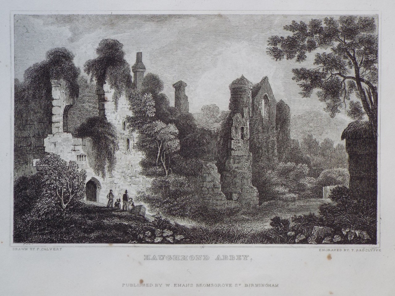
1783: Haughmond Abbey, Shropshire. Source: RareOldPrints
And 48 years later:
1831: Haughmond Abbey, Shropshire. Source: RareOldPrints
Haughmond Abbey (Google Maps), (Google Streetview), (OpenStreetMap), (Flickr images)

1776: Dryburgh Abbey Source: RareOldPrints
Dryburgh Abbey (Google Maps), (Google Streetview), (OpenStreetMap), (Flickr images)

1784: Chapel of St Pancras, St Agatha's, Canterbury Source: RareOldPrints
St Agatha's, Canterbury (Google Maps), (Google Streetview), (OpenStreetMap), (Flickr images)

1785: Cleve Abbey Source: RareOldPrints
And 59 years later:

1844: Cleve Abbey Source: RareOldPrints
Cleve Abbey (Google Maps), (Google Streetview), (OpenStreetMap), (Flickr images)

1786: Haverford West Priory Source: RareOldPrints
Haverford West Priory (Google Maps), (Google Streetview), (OpenStreetMap), (Flickr images)

1786: Byland Abbey Source: RareOldPrints
And 20 years later:

1806: Byland Abbey Source: RareOldPrints
And 42 years later:

1848: Byland Abbey Source: RareOldPrints
Byland Abbey (Google Maps), (Google Streetview), (OpenStreetMap), (Flickr images)

1860: Bayham Abbey Source: RareOldPrints
Bayham Abbey (Google Maps), (Google Streetview), (OpenStreetMap), (Flickr images)

1787: Burnham Abbey Source: RareOldPrints
Burnham Abbey (Google Maps), (Google Streetview), (OpenStreetMap), (Flickr images)

1800s: Kirkstall Abbey Source: RareOldPrints

1804: Kirkstall Abbey Source: RareOldPrints
And 30 years later:

1834: Kirkstall Abbey Source: RareOldPrints
How did so much soil move into Kirkstall Abbey's cellar?
Kirkstall Abbey (Google Maps), (Google Streetview), (OpenStreetMap), (Flickr images)
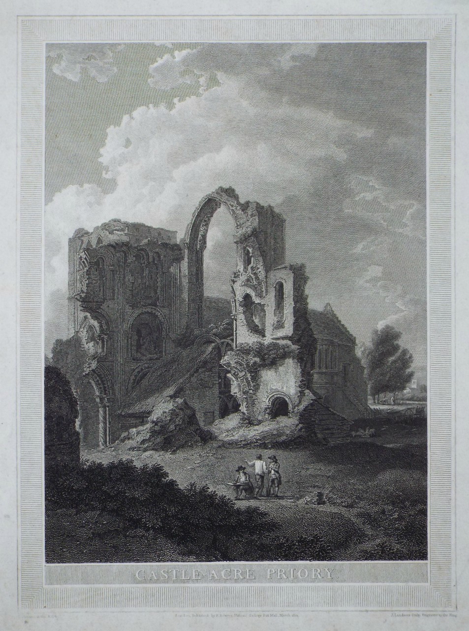
1801: Castle Acre Priory Source: RareOldPrints
Castle Acre Priory (Google Maps), (Google Streetview), (OpenStreetMap), (Flickr images)

1803: Cerne Abbey Source: RareOldPrints
Cerne Abbey (Google Maps), (Google Streetview), (OpenStreetMap), (Flickr images)

1805: Dunstable Priory Church Source: RareOldPrints
Why is the ground in front of Dunstable Priory's main arch so uneven?
Dunstable Priory Church (Google Maps), (Google Streetview), (OpenStreetMap), (Flickr images)
Many of these images show similar partially buried main doors. We shall see the churches hadn't sunk; the ground level had risen. The churches are simply the parts made usable again in the 19th century:
Mudflooded St Nicholas church, Great Yarmouth. Source: Words, buried in Time

1807: Easby Abbey Source: RareOldPrints
And five years later:

1812: Easby Abbey Source: RareOldPrints
And 39 years later:

1851: Easby Abbey Source: RareOldPrints
Easby Abbey (Google Maps), (Google Streetview), (OpenStreetMap), (Flickr images)

1800: Beaulieu Abbey Source: RareOldPrints
And 20 years later:

1820: Beaulieu Abbey Source: RareOldPrints
Beaulieu Abbey (Google Maps), (Google Streetview), (OpenStreetMap), (Flickr images)

1824: Bildewas Abbey Source: RareOldPrints
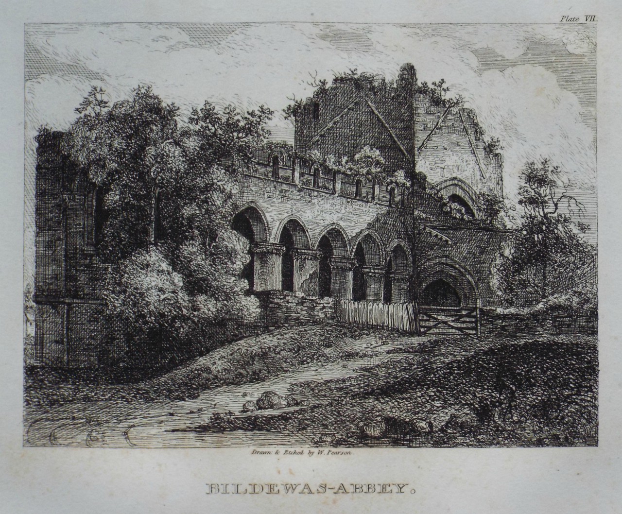
1824: Bildewas Abbey Source: RareOldPrints
Again, pay attention to the amount of soil that has mounded up around the ruin.
Bildewas/Buildwas Abbey (Google Maps), (Google Streetview), (OpenStreetMap), (Flickr images)

1829: Bolton Abbey Source: RareOldPrints
And 21 years later:

1850s: Bolton Abbey Source: RareOldPrints
Bolton Abbey (Google Maps), (Google Streetview), (OpenStreetMap), (Flickr images)

1773: Tintern Abbey Source: RareOldPrints
And 27 years later:

1780: Tintern Abbey Source: RareOldPrints
And four years later:

1784: Tintern Abbey Source: RareOldPrints
And 20 years later:

1804: Tintern Abbey Source: RareOldPrints
Undergrowth or soil piled up in front of the arch on the right? If it's soil, how did it get there?
And 26 years later:
1830s: Tintern Abbey Source: RareOldPrints
Tintern Abbey (Google Maps), (Google Streetview), (OpenStreetMap), (Flickr images)
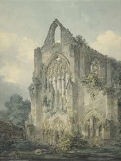
1778: St Marys Abbey, York Source: RareOldPrints
Undergrowth or soil piled up to the right of the people? If it's soil, how did it get there?
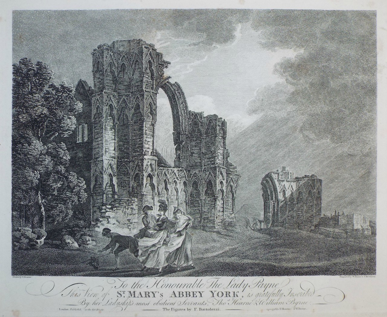
And 66 years later:

1844: St Marys Abbey, York Source: RareOldPrints
St Mary's Abbey, York (Google Maps), (Google Streetview), (OpenStreetMap), (Flickr images)
"Various states of disrepair..." in 18th century Leicestershire. Source: Pugin's Radical Restoration of St Mary's Wymeswold, Leicestershire
Finally...

South Gate. 1785. Source: Rye, East Sussex
In Rye's case, we're given a narrative.
From Rye, East Sussex:
the sea and the river combined in about 1375 to destroy the eastern part of the town and ships began use the current area (the Strand) to unload their cargoes. Two years later (1377), the town was sacked and burnt by the French, and it was ordered that the town walls be completed as a defence against foreign raiders.
Something about the sea and Rye's river - the Rother - changed in around 1375. And shortly after that, french invaders burned the town. Shortly after that, new walls were built. Which became ruined and overgrown some decades before 1785. Ruined and overgrown despite the town allegedly being a populated, well-located port on the other side of the English Channel from various wars on mainland Europe.
Locations of places imaged in this piece.
© All rights reserved. The original author/creator of each image, video, quote or text retains full ownership and rights.
![]() More of this investigation:
Depopulated England,
More of this investigation:
Depopulated England,
![]() More of this investigation:
The Reformation was a Reformatting
More of this investigation:
The Reformation was a Reformatting
![]() More by tag:
#geology
More by tag:
#geology