Lincoln's Newport Arch hints at a new date for Roman England. A very new date. Wed 10 November 2021
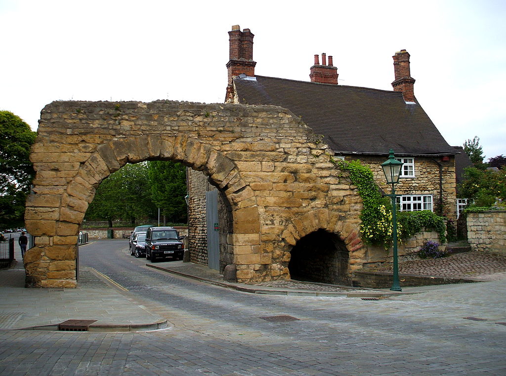
South side of Newport Arch in 2013. Source
The arch was a ruin when Nathan Drake painted it 250 years ago:

South side of Newport Arch in 1756. Source: Usher Gallery
But even then its dressed stone facing still looked quite intact.
That's odd. For two reasons:
-
From Note on Roman Antiquities at Lincoln, C Roach Smith, Journal of the British Archaeological Association, Vol 46:1, 1845, p54:
I had good opportunities of noticing how very much the buildings of Lincoln are indebted to the facing-stones of the Roman town-walls, which must have served as a quarry for ages.
-
No coping stone protected the top of the ruin by this time. So rainwater landing on top of the wall should have penetrated the mortar between the stones - as well as any cracks in the stones. When the water froze in winter, it should have expanded and spalled off the surface face in a few decades.
Especially during the so-called 'Little Ice Age' that the arch had just gone through.
Although vegetation grows on the top of the ruin in Drake's painting, most of the ruin is clearly visible. It is as though no-one cleaned it - or weeded it - since it was dug out out of the ground in around 1722.
By 1816, we see the top of the ruin has now been robbed (presumably) of stone so that its height above the arch-top is about the same as it is today:
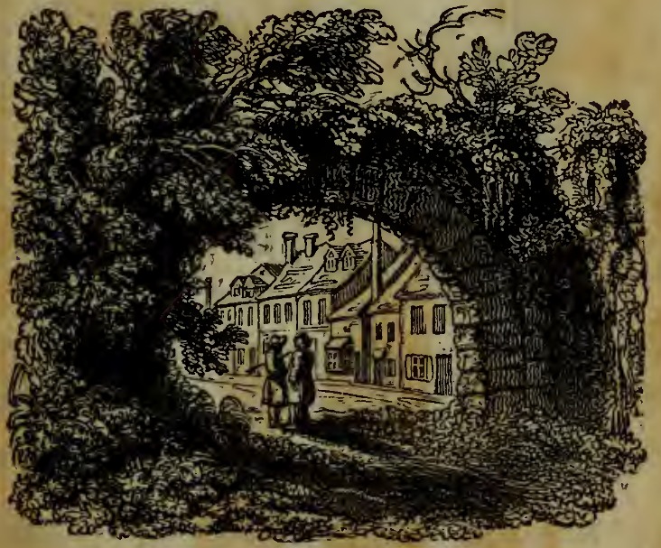
North side of Newport Arch in 1816. Source: The History of Lincoln
And it is much more overgrown.
The image suggests the arch had seen a second period of neglect. The order seems to have been that stones had been robbed, after which the arch was left entirely alone.
The 1816 image was made shortly after the end of the Holy Roman Empire. And the end of the Napoleonic Wars.
51 years later - in 1865 - a photograph shows the facing of the south wall:

South side of Newport Arch. Approx. 1865. Source: Newport Arch - Wikipedia
The vegetation has been removed and the wall of the arch looks about as rough as it does today. Presumably the damage since Drake's 1756 painting is due to a combination of freezing water, vegetation and, possibly, the processes involved with removing vegetation.
So Newport Arch hasn't aged much in the last 150 years.
- How old did the stonework of Newport Arch look in 1756, when it was (allegedly) 1,500 years old?
- How old did the stonework look in 1816, when it was 1,570 years old?
- How old did the stonework look in 1865, when it was 1,600 years old?
- How old did the stonework look in 2013, when it was 1,760 years old?
Newport Arch seems to have aged most in the 111 years between 1756 and 1865. Vegetation was just starting to grow on it in 1756. Then, in the 60 years between 1765 and 1816, the arch became quite overgrown.
Put another way, the conventional narrative suggests the aging of Newport Arch suddenly accelerated when it was around 1,500 years old, then stabilised again when it was 1,600 years old.
An unconventional narrative would suggest Newport Arch was severely damaged not so long after it was built. Perhaps within one or two centuries. It was then partly buried and dug out early in the 18th century.
Then abandoned until around 1816.
It has deteriorated at a normal rate for a building without a roof since then.
Locations in this evidence collection.
- Newport Arch, Lincoln (Google Maps), (Google Streetview), (OpenStreetMap), (Flickr images)
- Falerii Novi, Italy (Google Maps), (Google Streetview), (OpenStreetMap), (Flickr images)
© All rights reserved. The original author/creator of each image, video, quote or text retains full ownership and rights.
![]() More of this investigation:
The Reformation was a Reformatting
More of this investigation:
The Reformation was a Reformatting
![]() More by tag:
#geology
More by tag:
#geology