In the 17th century, huge drifts of sand covered farms and villages from Norfolk to Yorkshire. Where did they come from? Sat 30 April 2022
Coversands of England. Mark Bateman's 1995 map. Source
From The diary of John Evelyn, Vol II, John Evelyn, ed: William Bray, published 1901, entry dated 10 September 1676, p119:
[Henry FitzRoy, 1st Duke of Grafton] would himself have carried me to ... the Traveling Sands, about ten miles wide of Euston (Suffolk), that have so damaged the country, rolling from place to place, and, like the Sands in the Deserts of Lybia, quite overwhelmed some gentlemen's whole estates
Location: Euston, Suffolk: (Google Maps), (Google Streetview), (OpenStreetMap), (NLS), (Flickr images)
From Thermoluminescent Dating of the British Coversand Deposits, MD Bateman 1995:
Four main coversand deposits exist in Britain.
The eastern three of these allegedly 11,000 year-old Ice Age deposits began to drift across England again in the 17th and 18th centuries.
From The origin and age of coversand in north Lincolnshire, UK, Bateman:
Arguably the best exposures of UK coversands are to be found in northern Lincolnshire, west of the Lincolnshire Wolds, where there are extensive coversand deposits up to 7 m thick.
Three coversand patches are lined up along eastern England, including the 'Traveling Sands' Evelyn reported.
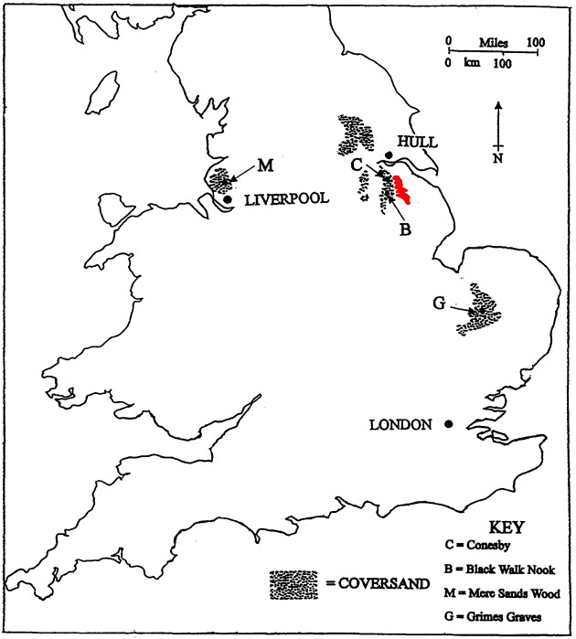
Let's look at the enigmatic eastern coversands. Starting with Yorkshire:

Bateman's Yorkshire coversand patch. Map source
The map understates the extent of English coversands. The Yorkshire patch spreads eastwards to West Heslerton almost at the Yorkshire coast. The sand buried so many villages that the area is alleged to be the world's largest archaeological dig.
Thick, windblown sand covered the villages. But when? Source: Is The Anglo-Saxon Invasion Of England A Myth?
Location: West Heslerton: (Google Maps), (Google Streetview), (OpenStreetMap), (NLS), (Flickr images)
A few miles south, "flying sand hills" were drifting across 17th century north Lincolnshire:

Gainsborough-Newark sand patch, circa 1695. Source
From The diary of Abraham de la Pryme, the Yorkshire Antiquary, Abraham de la Pryme, 1697, p58, 1695-06-11:
About this time I was sent for into Lincolnshire, to Roxby, about a liveing. Having passed over the Trent at Althorp, or Authrop, in my going to the aforesayd town, I saw nothing observable but the barrenness of the country, and the sandy commons that I passed over ; which I no sooner saw, but it brought into my mind the sandy desarts of Egypt and Arabia, which I had a most clear idea of when I beheld these sandy planes. For here the sand is driven away with every wind, and when the wind is strong it is very troublesome to pass, because that the flying sand flys in one’s face, and shoos, and pockkets, and such like, and drives into great drifts, like snow-drifts.
This sandy plane is some miles in length, and about a quarter of a mile in bredth. In great winds it does great damage, for sometimes in a night’s space it will cover all the hedges that it is near, and cover all the corn land adjacent, etc. I have observed huge hedges quite sandyd up with it to the very top ; and a cloas of thistles that was one day almost a yard tall, the wind changing, and I returning the same way the next day, I could but just discover the tops of them. This plane was formerly a much higher country than it is now, for here and there are left a few hills (now we may call them) three yards in height perpendicular, which blows away by degrees, but were formerly eaven with the rest of the blown away land, etc.
Location: Althorpe: (Google Maps), (Google Streetview), (OpenStreetMap), (NLS), (Flickr images)
Roxby: (Google Maps), (Google Streetview), (OpenStreetMap), (NLS), (Flickr images)
On p148, de la Pryme comments:
Upon the top of the great ridg of the flying sand hills as you go from Santon (now Lower Santon) to Burton market, in Santon parish, has been a great treasure of old copper coins hid; they have frequently been found there by whole handfulls, but are all so eaten away that nothing can be observed upon them. There was in the sayd sands, not long since, a fine wrought cross found, also of copper, about a foot and a half long, etc.
The sand seems to have settled by 1816, observed the anonymous author of The history of Lincoln - containing an account of the antiquities, edifices, trade, and customs of that ancient city - an introductory sketch of the county, 1816.
From its Introduction, p4:
Between Gainsborough and Newark a large tract of flat sandy soil extends for twenty-five miles.
20 miles or so to the east, another 17th century sand patch was engulfing the village of Nettleton.
From The diary of Abraham de la Pryme, the Yorkshire Antiquary, Abraham de la Pryme, 1697, p67:
I went to Nettle[ton], a little mile, to see something there that I thought memorable. All along the hill side there, for at least a mile, lyes a long bed of sand, which has sprung somewhere thereabouts out of the ground, and encreas'd to the aforosayd bigness, having cover'd a great quantity of good ground, and by that means undone several poor people. Within these twenty years it begun to move towards this town, and all that part of it that layd close to the hill edge (which was about twenty-five houses, with their folds and garths) has been destroy'd by it this several years, onely there is one house, which is a poor man's, that has stood it out by his great pains and labour ; but as for his folds and gardens they are all cover'd. It had destroy'd a great deal more of this town, but that, betwixt it and the aforosayd houses that were destroy'd, there runs a strong water spring, or brook, which it cannot get over, neither can it fill it, for as soon as any great rains falls, either in summer or winter, upon the hills, it dissends through this brook, and soon washes it to its old channel again, etc. So that this quicksand, not being able to get over, it goes all along by its side and the side of the hill, and last year broke a great hedge down, and has begun to enter into a piece of excellent ground, which it will most certainly destroy. And this was the memorable thing that I went to see. I have read in the Transactions of the Royal Society of a such like sand in the borders of Norfolk, which has almost destroy'd a whole town ; but that moves southward, as I remember, but this northward.
(Original editor's note: Three pages missing from here) 1

Bateman's 1995 map shows Pryme's east Lincolnshire sand patch grew much more than a mile long. Map source
Location: Nettleton, Lincolnshire: (Google Maps), (Google Streetview), (OpenStreetMap), (NLS), (Flickr images)
70 years later, south of Lincolnshire, the Norfolk villages of Brandon and Santon Downham were buried beneath up to six metres of sand. From The Brecks Earth Heritage Trail, page 8:
"Nothing was to be seen on either side but sand and scattered gravel without the least vegetation; a mere African desert", wrote William Gilpin, when passing through Brandon in 1769.
From page 3:
Sand storms were once a regular occurrence, such as one which engulfed Santon Downham in 1668.
From page 8:
In the 1660s, Thomas Wright wrote about a ‘Sand-Floud’ that had originated in the Lakenheath and Wangford area and eventually engulfed the village of Santon Downham, almost blocking the Little Ouse river. A brown stone in the south-west corner of St Mary’s Church wall is said to mark the height reached by the sand.

The brick is 6m (20ft) high. Source: Santon Downham St Mary
Sand to that height would almost completely cover the main church building behind the tower.
Location: Santon Downham: (Google Maps), (Google Streetview), (OpenStreetMap), (NLS), (Flickr images)

Orthodox science wants you to believe this was once - presumably - a small but tall tower of sand on the site of a future American air base. Map source
The Norfolk Breks sand was eventually stabilised in the early nineteenth century by planting trees on it and calling it Thetford Forest. See [Ice Age Sites of Britain's Serpents - Part Four]](ice-age-sites-britains-serpents-part-four.html#thetfordforest)
But it takes more than nine million trees to cover a renegade geological problem. It takes information management:
"But we don't have any evidence for that I'm afraid." Source: BBC Radio 4 - Making History, 2009-10-12
Yes, at 2 minutes, 50 seconds they managed to stand next to a 6m high sand deposit and then conclude - at 6 minutes - there is no evidence Santon Downham was once buried by a 6m high sand deposit.
Summary Data
Dates, locations and alleged sources of coversands:
| Sand-flood Year | Location | Source of sand |
|---|---|---|
| 1270-1650 (multi-century event) | Kenfig, Wales | From Irish Sea/Bristol Channel |
| 1610 (multi-decade event) | Santon Downham, Suffolk | Wind blew it from a warren at Lakenheath (owned by Dean and Chapter of Ely) |
| 1694 (disputed multi-decade event) | Culbin, Scotland | Originally from hills above/River Findhorn watershed, then wind from the north west |
| 1694 or 1695 | Scunthorpe, Lincolnshire | Wind-driven from unspecified location to west |
| Unknown | Mere Sands Woods, Lancashire (Location 'M' in the coversands map) | Ambiguous but from west, presumably Irish Sea |
| Unknown. Before 1812 | Crantock, Newquay, Cornwall | Irish Sea |
All but one of the sands' original sources were sea or an area that had been flooded. The one exception is Lakenheath, Suffolk, whose name obviously suggests it had been a lake.
Locations affected by recent sand floods.
Key:
- Blue marker: sand-affected locations mentioned above.
- Red marker: alleged sources of sand
Other Enigmatic British Sand Floods
1. Culbin, Scotland
From The Storm of 1694:
It came suddenly, and with little warning.
The drift came on steadily and ruthlessly, covering every object in a mantle of sand. Everything which obstructed its progress speedily became the nucleus of a sand mound.
This description is very similar to a 1668 account of the long-lasting sand flood over Suffolk's Santon Downham in A Curious and Exact Relation of a Sandflood....
Continuing with Culbin...
From The Girnel of Moray:
The mansion house was in keeping with this handsome income. It was a large square building of dressed stones, set amongst rows of shady trees, with a prolific garden, a spacious lawn, and most fruitful orchard. As a Barony, it had doocot which stood on a little eminence by the house. There was a church at Chapelhill.
From How a storm-stricken Scottish village was swallowed by sand:
Apart from the chimney of the mansion appearing above the sand a century later, which entertained visitors to this strange landscape, little was done to reclaim the desert until the Forestry Commission began to plant pine trees in the 1920s.
From Re-emergence:
About 1920, sand stone blocks bearing part of the family coat of arms were found, and during the 1930s a complete outline of foundation stones was exposed a short distance north-west of Kincorth (possibly a typo meant to read 'Kinloss').
Alas, the precise location was not recorded.
Possible location of Culbin's manor house: (Google Maps), (Google Streetview), (OpenStreetMap), (NLS), (Flickr images)
Eliza Gordon-Cumming - sister of Loch Nell serpent mound proponent Constance - wrote the sand-drowning of Culbin as a poem.
From Fact, Fiction and Tress, quoting Ross Sinclair:
And myths about the local laird (Alexander Kinnaird) playing cards with the devil are common to several other parts of Scotland with similar dune areas.
His dramatic appeal to Parliament in 1695 blossomed into the legend of the 'Buried Barony', and fired the imagination of writers into keeping the tale alive.
Perhaps the card game stories were created by the Gordon-Cumming sisters to romanticise an all too real landscape reformatting.
- Culbin, Scotland: The Great Sand Drift of 1694
- Location: Culbin: (Google Maps), (Google Streetview), (OpenStreetMap), (NLS), (Flickr images)
- Culbin folklore
- Culbin stories
- The Culbin Sands - A Mystery Unravelled
- Abandoned Communities
2. Kenfig, Wales
- Abandoned Communities - Kenfig
- the Kenfig Society
- Kenfig Pool - Wikipedia:
There are several theories about how the [Kenfig] pool was formed. An old, yet popular theory claims that the lake was created during a "sinking of the land" in a massive earthquake, but has since been rejected as downright bizarre
When historian Rhys Merrick visited during the time of Elizabeth I, and enquired about a lost medieval town in the vicinity, some told him (correctly) that it lay near the castle, but others said it had "sinked and become a great mere" - Kenfig Pool. The story goes that a vast and prosperous city lay beneath the lake.
Location: Kenfig, Wales: (Google Maps), (Google Streetview), (OpenStreetMap), (NLS), (Flickr images)
3. Newquay, Cornwall
From Voyage Round Great Britain, Richard Ayton, William Daniell, 1813, published 1978, p24:
... we turned our boat's head towards the land, and entered the Ganal Creek, where a narrow arm of the sea runs inland about two miles, and is joined by a small river, which rises in the parish of Newlyn, near Trerice. This creek was formerly more considerable than it is at present, but has received a more than common share of the mischief that pervades every haven on the Cornish coast, and is so blocked up by the sand forced into it by storms from the north and west, that it cannot admit vessels of more than thirty tons. Near the mouth of the Ganal there is a little village, called Carantoc (now Crantock but formerly Lanngorrow and Langurroc), which, like other places inhabited only by the poor, is mean and dirty.
Here, was anciently a large town, and a collegiate church, dedicated to St. Carantocus, a disciple of St. Patrick ; and here too, where now little meets the eye but a cheerless desert of sand, once stood a college, which could boast of as high antiquity, if not of as high repute, as any college at Oxford.
From Crantock:
Langurroc was infamously (among locals) covered up in a sandstorm and may well lie beneath the sand dunes which back Crantock Beach.
The church was collegiate from ca. 1236 to the Reformation.

Dunes backing Crantock Bay. Source: Crantock
From Newquay:
By the 15th century, a village referred to as “Keye” existed around the present harbour, near “Tewynblustri” (the spelling changed as Cornish evolved and is now rendered as “Towan Blystra”). “Towan” (or Tewynn) means dune or sand hill in Cornish, but the meaning of “blustri” or “blystra” is unknown.
To the north of the harbour there were fish cellars in the 19th century, where pilchards were salted and packed in casks. The two remaining areas are Fly cellars and Active cellars, although the others have disappeared.
The meaning of "blustri" or "blystra" is almost certainly: "Blood Street", "Blod Street" or "Blodstone" - as in "bluestone".
Location: Newquay, Cornwall: (Google Maps), (Google Streetview), (OpenStreetMap), (NLS), (Flickr images)
4. St Enodoc, Cornwall
See On the Level About Lincolnshire - Part Two.
More:
You know 'Late Holocene' is a euphemism, right?
- Late Holocene landscape instability in the Breckland (England) drift sands
- Late-holocene inland dune activity in the UK: a case study from Breckland, East Anglia
- Endless cold: a seasonal reconstruction of temperature and precipitation in the Burgundian Low Countries during the 15th century based on documentary evidence
- A medieval settlement caught in the sand: optical dating of sand-drifting at Pulle (N Belgium)
- Fighting drift sands with pine trees: Reforestation of coastal areas of NW Portugal at the end of eighteenth century
- Diary entry for 10 September 1667, Diary of John Evelyn, Vol II, p119 (and also p71 and p117)
- The birth of a desert. The Kootwijkerzand
- Large-scale transgressive coastal dune behaviour in Europe during the Little Ice Age
- Late Holocene Aeolian Drift Sands in Drenthe (the Netherlands)
Further away:
© All rights reserved. The original author/creator of each image, video, quote or text retains full ownership and rights.
-
The Diaries's editor noted the manuscript had apparently been redacted - censored - here. ↩
![]() More of this investigation:
The Reformation was a Reformatting
More of this investigation:
The Reformation was a Reformatting
![]() More by tag:
#geology
More by tag:
#geology