England's missing castles hint at two well-kept secrets. Sat 19 March 2022

Bodiam Castle. Cattle-pen for sentient livestock. Source: Bodiam
The Romans built castles where they feared the Anglo-Saxons might invade:
As long as the Saxons didn't go around them. Source: Is The Anglo-Saxon Invasion Of England A Myth?
We're told the Romans were specially careful to fortify England's east coast rivers, such as Norfolk's estuaries. Now called the Norfolk Broads:

Norfolk's Roman forts. Source
But...
From History of Lincolnshire:
Given the size of Lincolnshire, historians note the relative lack of castles
Not to mention the fantastic water access Lincolnshire offered to invading armies. After the Romans, England's (alleged) invasion sequence goes like this:
- the Saxons - from 450 AD to the early 600s AD
- the Vikings (Danes) - from the late 700s AD to 1069 AD
The Danes invaded and re-invaded England right up until the Normans invaded. Viking-Danish invasions favoured eastern England's coastal rivers, especially the Humber.
So why didn't William the Conqueror build forts near battle-tested Viking invasion routes like the Humber?

Mind the gap William. You'll let the Danes back in. Source: Historic UK
Apparently because in 1066 those routes were - at their driest - swamp:

UK Viking settlement in AD 878. Source: The Battle of Edington
- Look at the southern Fens. One of the little red islands was the now-inland port of Ely.
- At the southern edge of the Fens was a port called Waterbeach, now inland a few miles north of Cambridge.
- North of the Fens, an estuary reached up past the Lincolnshire ports of Swineshead, Garwick (now East Heckington) and Horncastle. As far as tidal Lincoln.
- The Welland estuary reached inland west of the Fens to the port of Stamford.
And not just the fens. Note the brown patches around Ripon and York, between Richborough and east Kent, at Romney in southern Kent, and at the Somerset Levels on the southern side of the Bristol Channel...
Those brown patches were sea.
How do we know they were sea?
The labels on the next map help us investigate.

Brown indicates sea or swamp in around 1,000 AD. Source: Carhampton
In the above map, just under the word 'SUSSEX' near the south eastern corner of England, the Rother estuary ran inland past Bodiam castle to the small Sussex village of Robertsbridge. It also ran further north to Oxney and Small Hythe in Kent.

From Tenterden in Kent: Town Guide:
It is difficult to believe today that Tenterden had access to the sea at Smallhythe, since the coastline has altered so much. Using the wood from the Wealden Forest as its source of timber, Smallhythe was a centre for shipbuilding and produced wooden ships that were large for the time.
Time Team also investigated how medieval England's second biggest medieval freight ship - the 1,000 ton 'Jesus' - could have been built at Small Hythe, Kent:
The Rother estuary. It just sort of 'silted up'. Source: Time Team: Small Hythe
How many locks are there on the Rother?
None.
So why doesn't the sea still flood it?
Because sea levels have fallen.
But you're supposed to say: "the coastline has altered".
The Great Storm of 1287 (St Lucia's floods) destroyed the inland ports of England's south coast. And completed the flooding of Holland's Zuider Zee:

Zuider Zee around 1658. Source
So, according to mainstream historians, England's brown areas just sort of silted up. Except in Holland, where they became the Zuider Zee.
Admitting these areas were tidal ports would prompt waking minds to wonder where that much silt came from. And why it started moving downhill into former estuaries. So orthodox history is only very slowly admitting those brown 'swamps' were sea.
That's the first mystery solved: the Normans did build castles on England's eastern coasts. The defences don't show up today because in many places 900 years ago, the sea reached much further inland.
Moving on to a second mystery, if the Danes were the primary east coast threat, why did the Normans build so many castles inland and near England's western borders? Did the sea come in that far? Were the Welsh so powerful? Did they fear Irish invaders? Inuit invaders? The native Americans?
Trade in goods, you say? Source: Is The Anglo-Saxon Invasion Of England A Myth?
Which goods?
The usual answer is:
Grains. Source
But farmers store grain in cheap, maintainable covered silos. For weather-protection and vermin control. Not in complex structures like castles.
Let's consider a different harvest. Let's turn to Norfolk again. In the early 17th century, Heacham's John Rolfe emigrated to the US and found work managing sales in the early days of Britain's African-American slave trade.
From Heacham, Norfolk, England:
In about 1619 John Rolfe, a native of this village, wrote from Jamestown, Virginia, to Sir Edwin Sandys, treasurer of the Virginia Company of London, with the first record of African slaves arriving in North America.
He (it's not clear who 'he' is but it seems to be Rolfe) brought not any thing but 20 and odd Negroes, which the Governor and Cape Marchant bought for victualls...
Today, John Rolfe is better remembered for marrying native American Pocahontas and creating Britain's 'special relationship' with north America. That would be the Pocahontas who saved Jamestown - the town whose evidence of recent child cannibalism emerged in 2012.
'Victualls' is a naval term for 'food':

"How a slave was killed and eaten." Plate 16 from America, Vol. III, 1592, Frankfurt. Source: Black Legend Cannibalism
Apparently, Rolfe was selling newly-delivered Africans as food to customers like the Governor of Virginia - presumably Francis Wyatt - on behalf of the Virginia Company of London.
Perhaps we can now make sense of this:
Source: The Old World Enslaved Trade
Specifically, 'victualls' meant salted and dried meat suitable for ships' provisions.
Human meat and materials as a response to catastrophe.
Not to pick on Heacham - or any other place where John Rolfe hung out - but when British archaeologists were studying butcher's marks on the baby carcass found at Yewden, Buckinghamshire, one of their references was an unpublished paper describing the legs of a butchered child found at Heacham.
And also near Heacham, from Walking on Buried History, Charles Lewton Brain, Larks Press, 2009, p69:
On another curious occasion I was digging out some early Iron Age rubbish pits which had originally been made for grain storage, and in one of them was a quantity of human bones.
one suspected possible cannibalism, as our ancestors were not all that fussy. In a nearby area were the remains of a fire, and in the charcoal the skeleton of a girl about 11 years old and a small pig, together. Both were headless - again - no explanation.
A strange landscape feature north of Heacham also helps confirm a cover-up of cannibalism in eastern England during the Little Ice Age: Ringstead Downs.
To better appreciate Ringstead Downs, we should first be familiar with Ubley Warren - AKA Velvet Bottom - near Charterhouse in the Mendip Hills, Somerset.
Ubley Warren is an enigmatic valley a mile east of Somerset's most famous cannibalism site: Gough's Cave. In fact, it's even closer to Charterhouse Warren. There the bones of 37 cannibalised humans were found in the 1970s and discussed quietly until more public mention started around 2017.
It's the problem with how Ubley Warren valley looks and its dating 'enigmas' that challenge claims that any of these cannibals were 'prehistoric':
Just how do you date sediment exactly? Source: The Most Unsettling MYSTERY, No one can Explain...
Or even roughly?
Anyway, he's walking past the dams shown crossing Ubley Warren in this aerial photograph:
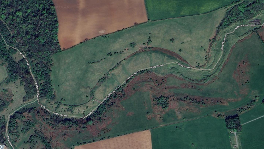
Valley of the Damned. Source: Google Maps
Here's how this artificially modified valley looks on a map:
Velvet Bottom, Ubley Warren, Somerset
Key:
- Blue lines: Ubley Warren valley edges
- Red lines: Remains of former dams
- Blue markers: Evidence of cannibalism found
Ubley Warren is presented as an artificially modified valley built during the 18th century's Little Ice Age, then back-filled by the Romans 1,300 years earlier.
Besides the (hopefully) obvious hint that sediment can't be 'Roman', let alone be Roman and be piled behind 18th century dams, what has Ubley Warren got to do with 18th century Heacham? And with Heacham home-boy John Rolfe and with plentiful evidence of cannibalism around Heacham?
This:
Ringstead Downs, Heacham, Norfolk
Key:
- Blue line: Ringstead Downs valley
- Red lines: Apparent remains of former dams
From Ringstead Downs - Wikipedia:
it is a dry chalk valley which was carved out by glacial meltwaters.
Ringstead Downs is how an allegedly natural valley looks on a map. This map would look even more like Ubley Warren's damned valley if trees weren't obscuring its artificial-looking edges and other dams.
The 'Ringstead Downs is natural' narrative baffles local dog-walkers, who note the consistent angles of its sides and the equally consistently angles of its 'dams', each of which holds back a flat plain of grass-covered sediment.
Because 'natural' Ringstead Downs looks exactly like artificial Ubley Warren. They'd be even more baffled if they know both valleys are close to remains of mass cannibalism.
A rational explanation is that both valleys are artificial, and were built in the 18th century with the help of Little Ice Age meltwater, then back-filled. Presumably by an event that left locals relying on each other for calories.
And that English archaeology is only slowly releasing evidence for the extent of English cannibalism and that it was recent.
However, if recent English cannibalism is news to you; it's not news to native Americans:
"It was used as a food supply going back and forth across the Atlantic." Source: Ivan Zlax
Video transcript:
Speaker 1: So, the church doctrine about eating any... meat on Friday... It was putting in to make sure that the people through generational would stop eating human steak. Or stop practising cannibalism.
Speaker 1: So you're talking about the people that were attacked that were cannibals? That's what they were.
Speaker 2: So cannibalism was going on before [cough] Columbus?
Speaker 1: Well yeah. Columbus. Er... He, er... It took ten years to kill all the Indians in the Caribbean.
Speaker 2: Cause they say that's when they say cannibalism first...
Speaker 1: No. That's way off... That's... All... It took ten years to kill every Indian in the Carribbean. You know they had Indians in the Carribbean?
Speaker 1: It took ten years because it was used as a food supply going back and forth across the Atlantic. And that's recorded documentation on this matter.
Fish Fridays aren't the only seemingly inexplicable Christian principle that makes most sense when understood as an effort to discourage cannibalism. After two millennia trading body parts as holy relics, Christianity outlawed the after-life for the butchered:
A choice between Heaven and the casserole. Source: The Vault of Skeletons on the Metropolitan Line
Other aspects of castles don't make sense:
- The military stupidity of locking yourself in an easily identifiable place with a finite supply of water, food and ammo is one.
- The association of castles with blood-sucking vampires - from Whitby to Transylvania - is another.
So perhaps Andrew is right. Their locations and structures make more sense when interpreted as livestock-holding pens.
Locations discussed in this evidence collection
Key:
- Blue markers: former ports
- Yellow markers: Other locations mentioned
More:
© All rights reserved. The original author/creator of each image, video, quote or text retains full ownership and rights.
![]() More of this investigation:
IHASFEMR
More of this investigation:
IHASFEMR
![]() More by tag:
#human leather, #human meat, #geology
More by tag:
#human leather, #human meat, #geology